I first heard of this trip a few years ago, when becoming involved with the Kaimai Ridgeway project. In 2015 the Auckland Tramping club had cut a new track that gave access to the old Pylon track and bypassed the Kauri Grove track, since partly closed by DOC. I had read a report of a track loop that went up the Pylon track, along the North-South track, and back down into the Waiorongomai valley, but found it hard to establish the level of difficulty – a real issue for some of us old codgers in the Wanderers Tramping Club. The only way to find out how we would go was to try it, so Grant and I did a survey a week or so before the planned day. I had several times been up to the main ridge, and had previously established a “plan B” which was to return from the ridge to the manageable but hard-to-find link to the North arm of the old Kauri Loop track. The survey was successful – the North-South track section was well marked, and cleared, although not of a high quality. Grant and I took 7 hours, so it was all on for the main group.
On the morning of the trip we ended up with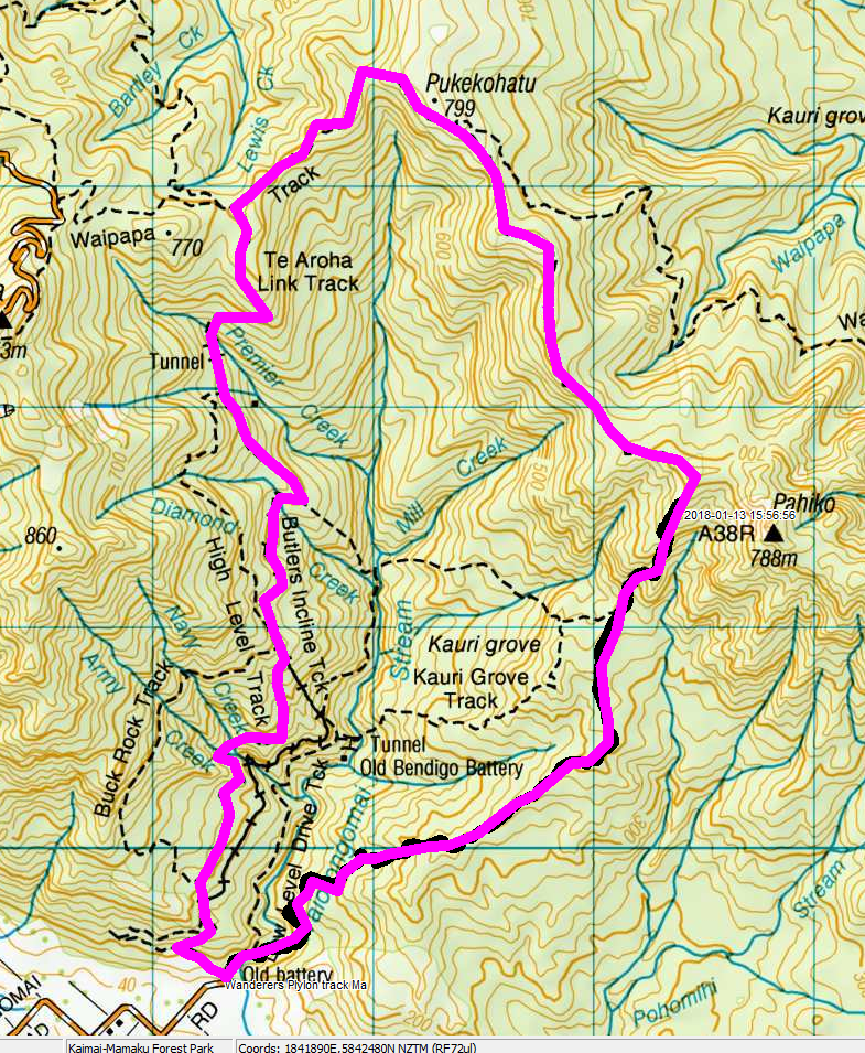 6 people in our own van – the 10 Grade 1 trip participants in the same area would not have to wait for us. The route starts off on the Waiorongomai low level track, but after a hundred metres drops off the side into the valley to the first obstacle – a stream crossing. Some of us strode through the water, but others chanced involuntary baptism by rock hopping, The grade is steady for a start, with one section along an old water race – Grant started to investigate the tunnel through the ridge because he knew where it came out, but decided to leave its exploration for another day.
The bush is mostly kanuka at the start, but then becomes more varied as altitude is gained. After about an hour we started to look out for the tape and string that marks the junction with the old track, and although I had it on the GPS I still missed it. I stopped when I realised I had gone too far, whereupon Carol said “I saw the blue string”. She did not realise its significance, so I explained Plan B to the group.
After about 2 hours we emerged on to the barren tops – a place where extra clothing was needed because of the wind. Some mist was around, but no rain. Views appeared under the cloud to the Hauraki plains. Another half hour and we were on the main ridge, which had shelter in the scrubby trees, and we conferred – do we grab an early lunch and resort to Plan B, or continue with the circuit, getting back to the van about 4pm or 5pm? Plan A it was, so I ploughed on, shaking the water off the vegetation so I got wet, and perhaps making it drier for my followers?
I knew there would be little shelter for lunch once we reached the Waipapa track, so when we encountered an open but sheltered area about midday I called a lunch halt. No views, but the vegetation (Dracopyllum latifolium(?), neinei) was mildly interesting.
Another hour and we reached the Waipapa track – what a difference! Well graded, cuttings, geotextiles emerging from the path showing advanced construction techniques. A quick trot for a while took us to the Te Aroha Link track, and then we were on the way down back to the van. It seemed to me we went further down than we had gone up, but that was unlikely.
Mining relics (a tunnel on to a bridge, the May Queen and Butler’s Inclines, and an old and large water powered air compressor) gave us excuses to rest as well as places of interest.
We eventually reached the van about 4pm, seven hours after our start. We all felt it was a very enjoyable way to spend a day, even if the weather only cleared as we reached the end of the tramp.
Total distance 12 km. Time taken 7 hours. Highest altitude about 750m. A .gpx file is available of the route.
Ray